It was a strange natural feature. It was a six-mile oxbow in the river that returned to within 66 feet of itself. The four-mile oval created by the North Fork of the Kentucky River’s run around a small mountain became known as the Panbowl for the unique shape it created.
The long swag in the ridge that led to the Panbowl became known as the Panhandle. The taller, more ragged section was known as “The Devil’s Backbone.” These features became famous as the gateway to Jackson for many. A small “dinky: train tract was installed and ran through the Panhandle, the PanBowl, and over Frozen Mountain to Keck.
A postcard view of a dinky train making its way across the Panhandle toward Jackson. Note the North Fork of the Kentucky River on both sides of the slender ridge known as the Panhandle.
In 1941, writers for the Works Progress Administration, a Roosevelt-era New Deal program, came to Breathitt County and wrote a brief history of the area. In the back of the work, they included Points of Interest from around the area. One of those points described by the writers was the Panhandle.
The PANHANDLE AND PANBOWL, one of the most fascinating spots in the environs of Jackson, is reached either by crossing the swinging or footbridge, at the foot of Court Street, or by crossing the highway bridge into South Jackson and then following the narrow dirt road that leads through the “Cutoff” and branches left on to the Panhandle and Panbowl. When seen from Jackson, the Panhandle has the appearance of a sway-back ridge. At each end, stone outcroppings tower starkly above the “saddle” of this narrow strip like relentless sentries on strategically placed forts.
Long famous as a curious natural phenomenon, it is the stem of that fan-shaped section of land around which the North Fork flows and almost returns upon itself. The swing begins at the bend of the river in the lower part of the town. Here many decades ago the river is said to have kept a straight course through the narrow defile of the Cutoff until it was filled in. The North Fork, from this point to a point where it swings away from the Cutoff on the opposite side, makes a detour of about seven miles.
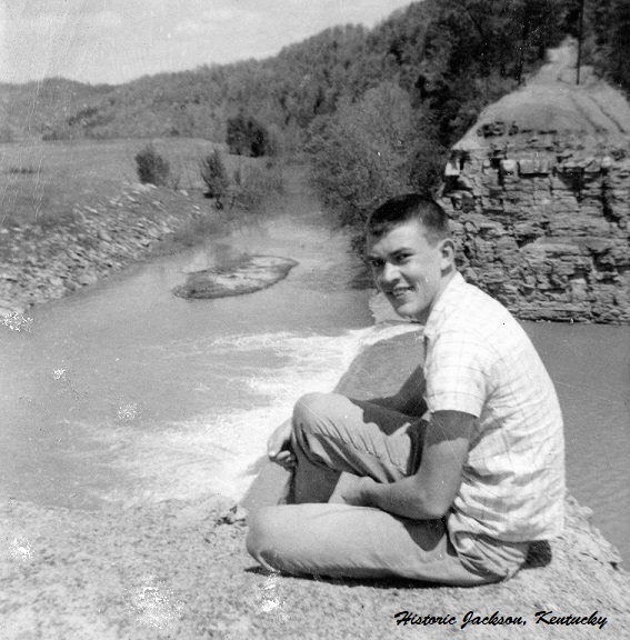
An unidentified teenager sits on the North side of the newly created Cut-Through about 1957.
At the Panhandle Tunnel, the ridge is only about fifty or sixty feet wide from base to base, while the tunnel itself is around forty feet in length. From this vantage, a panoramic view of Jackson and the surrounding country can be obtained. A variety of scenery unfolds in every direction. The North Fork flows gently on both sides. The fairly fertile bottom lands on the far side of the river, the swinging bridges that span it on both sides, the coal mine at the western end of the Cutoff, the wild vegetation and rugged outlines of the Panhandle, and the drab house on the bottom land below the tunnel, with its cow pen and pigsty, form a pattern in which natural beauty blends with human color.
The wagon road leading across the Panhandle forks when it reaches the rocks that stairstep to the top of the cone-shaped Panbowl Hill. The path that continues straight on up to the top branches at one point to the right and left. These branches lead to rock houses, one a deep but low sheltered rock ledge. “Indian Post Office,” the other rock house, is not as deeply sheltered as the first, but it has a naturally formed rock seat and numerous frost-eroded “pigeonholes.”
The name, “Indian Post-office,” was given to it because these pigeonholes, which suggest post office boxes, are sometimes used by the boys and girls of Jackson to exchange “blind” notes. The word “Indian” seems to have been tacked on to give it a primitive flavor. At another point this path extends for about twenty-five feet over a narrow strip, or “razorback,” just wide enough for a foothold.
A view of a few of the Post Office Boxes before they were blasted away for the Lakeside Road Project.
Along the path, there is a large, flat-topped boulder which affords a sweeping vista of the surrounding country. The topmost part of the hill, less rugged than the lower part, is covered with trees and sod. Beyond this point, a series of smaller hills slope toward the bottom lands that rim the North Fork around the bend.
The Panhandle and Panbowl touch off fanciful currents in the imagination. Myriad forms and colors, fantastically shaped rocks, half-veiled in the foliage of evergreens and the profusion of shrubs, form a wild symphony of nature. At sunset on windy days there is a Promethean touch to contemplation atop the largest of the cliffs. It is a heady spot where some ancient spirit still seems to brood. The Panhandle and Panbowl are equally suited to poetry, philosophy, romance, murder, or just plain exercise.
In the Land of Breathitt, 1941.
A view looking south down the Panhandle about 1913 after the dinky tracks were removed.
The Panbowl remains although it has been much developed since 1941, Two schools, a hospital, businesses, a major highway, and hundreds of homes can be found on the Panbowl today. The Panhandle did not fare so well. In the Spring of 1956, the contract was awarded to create a gorge, 70 feet deep, 200 feet wide, and 170 feet long to divert the North Fork away from the Panbowl and on downstream. The Cut-Through Project blasted away most of the Panhandle and the tunnel and created Panbowl Lake. With the destruction of the ridge to make way for the flood control project, the site of so many picnics and Sunday afternoon outings is now only a memory.
Thank you for this and other very interesting articles. Although, most of my grandfather’s family had left the area in the early part of the 20th century, his ties to the area run deep – back to the early 1800’s.


Thank you for this and other very interesting articles. Although, most of my grandfather’s family had left the area in the early part of the 20th century, his ties to the area run deep – back to the early 1800’s.
LikeLike