Northern Terminus to Morehead
Yep, I am at it again. The Sheltowee Trace has such a draw that I keep coming back.
I decided to go to Morehead to support the hikers doing the 2020 Challenge. I loaded my pack just in case there was room for me to hike with team Alpha- maybe as a sweeper or in any capacity that I could serve. I planned to join the Challenge at some point when the numbers dropped later in the year.
I was up and getting ready before my 4:30 a.m. alarm. Dressed and headed to the office to get some cash and inReach mini. Very excited, I left Jackson about 4:48 a.m. and headed to Morehead. It was overcast and the temperature hovered around 42 degrees.
I stopped at the West Liberty McDonalds for a sandwich and ordered. For more than 35 minutes, I sat at the window and watched as the workers stood and looked toward the grill, but no food came. In my mind, I was attempting to make it to Morehead by 6:00 a.m. to help organize the departure or help for the morning. After a long wait, I eventually just drove away from the window because I was on a tight timeline.
I might have slightly bent the suggested speed limit on the newly widened sections of Highway 519 between West Liberty and Clearfield. The slight increase in momentum got me to Morehead about 5:50 a.m. and I was shocked to find only a few people and vehicles in the parking lot at the Convention Center. The early shuttles were not there and I guessed that they had filled and left. Faithfully, STA President Steve Barbour was there and I discovered that the first group was not set to leave until 6:30 a.m. and that I had hurried for no purpose.
Several of us stood around in the parking lot and talked. I helped direct people to the “five-pound” drop zone in the back of the maroon Sheltowee Trace Association van and answered a few questions about terrain and procedures. We loaded the vans and left Morehead for the Northern Terminus.
We arrived at the trailhead shortly after 7:00 a.m. The hikers posed for a quick picture and headed down the trail. The temperate was 62 degrees and perfect for hiking as we set out at 7:18 a.m. to start the climb up to the ridgeline. Walked the morning away on the long series of ridgelines and did not see the sun until 8:10 a.m. when it finally found a small slit in the clouds and shined through.
The hike from the North Terminus to Morehead is one that I have completed several times and have found this walk to be beautiful. This nice hike was interrupted about 8.5 miles in by a shocking discovery. At 10:22 a.m., I crossed a roadway and discovered the impact of a logging operation that had devastated the woods in the area around Burnt House Branch.
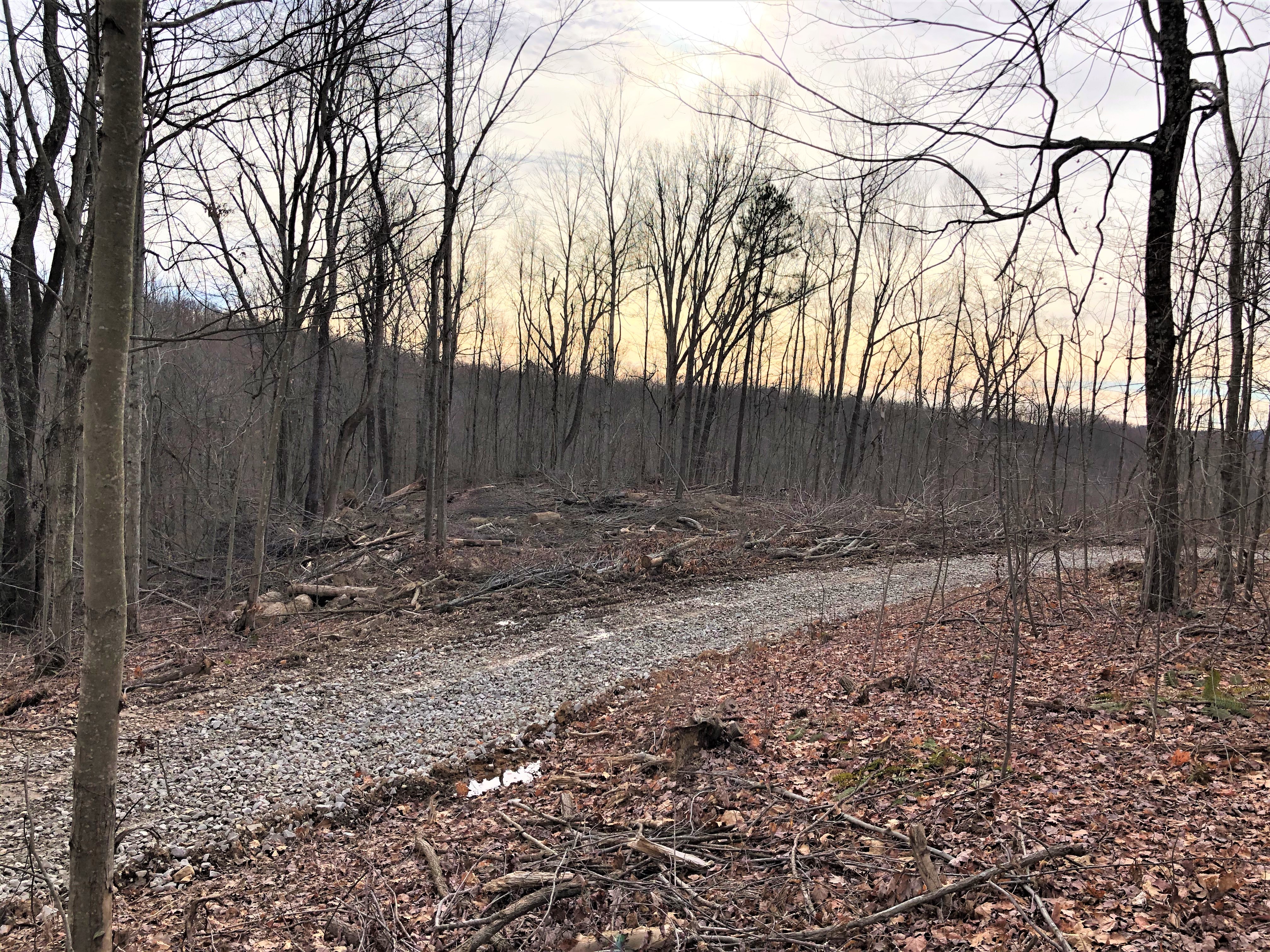
I understand the National Forest is a living entity. I understand that the timber is harvested regularly and that these reserves were made for this purpose. I support the ethical harvesting of timber and the appropriate plans to reforest these areas. I do not have an issue with this process. It was just a little shocking to see both sides of the Sheltowee Trace harvested. I hoped that the corridor could be undisturbed but that is not the case in this area. The Trace is a collection of public and private access. This area might be private (I am not sure), but I was still shocked to see and walk through this area of nearly clear-cutting activity.
Luckily, the time in the logged corridor was short and I walked down the hill onto the Clark Farm at Dry Fork at 10:38 a.m. A couple of us walked over to the Clark Family Shelter and checked the coolers for something to drink, but found only ice.
I left my hiking friends behind and climbed the steep hill to the gas line at the top. Crossed the hill and dropped over into Steep Cut Branch which runs into Holley Creek. I arrived at the blacktop at Holly Fork at 11:32 a.m. Steve Barbour and the STA crew had set up a white tent to cover the meal and to provide some cover for the evening. The sky was low and clouds raced quickly across headed nearly due east. The wind was not a major issue when I arrived. I walked down to the tent and sat down near tarps covering the “five-pound” drops to rest for a second.
Shortly, after I arrived a strong gust of wind lifted the white tent that Steve and the STA had erected for our rain protection and slammed it against the ground. I tried to raise it back up but the poles are bent terribly and I was afraid they would break with any applied pressure. From that moment, the weather decided to show up for the hike.
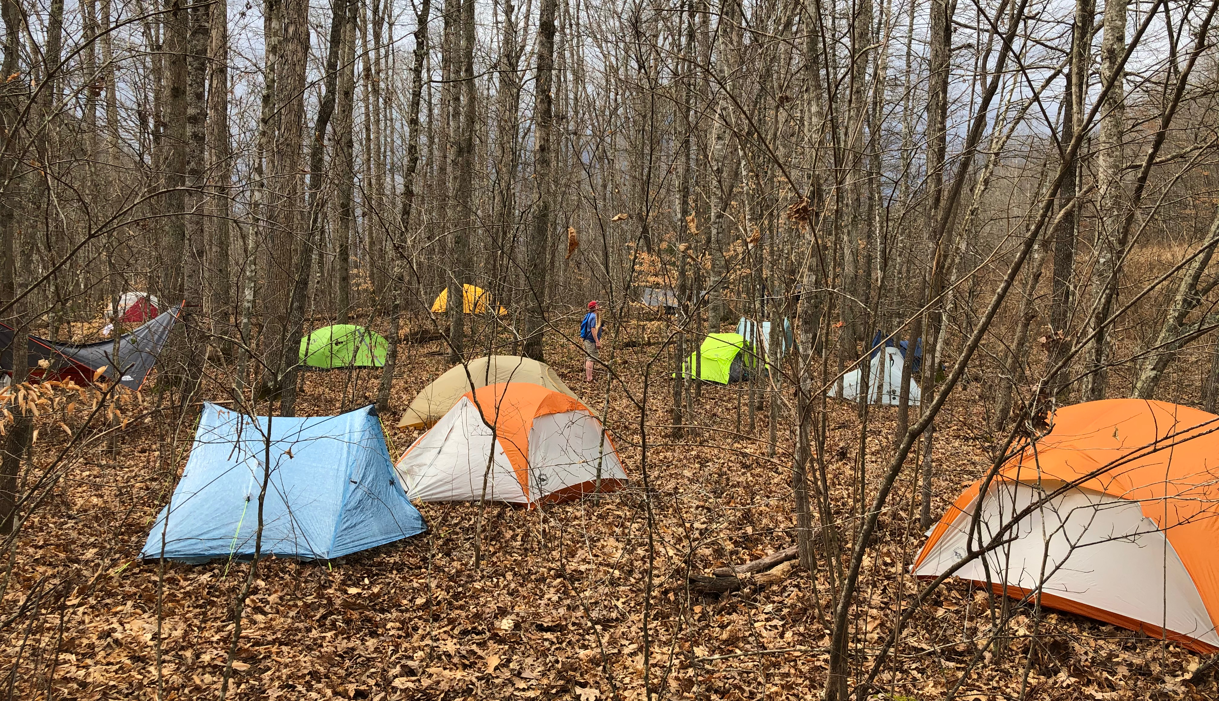
At 11:55 a.m. as I sat updating my trip log, the first sprinkles fell on the wooded area that would be our camp near Holly Fork Road. I set my tent up and made sure that everything was ready and well-anchored for the coming wind and rain. The first hikers behind me started to arrive at about 12:15 p.m. and eventually, the rest came in the rain and found places for tents and hammocks.

Marissa (Class of 2019) arrived to help with the event and slowly the camp was established. Bored, I decided to pick up some trash around the trailhead and across the field to the swinging bridge over Holly Fork. Worked with some hikers to set up tents, some of them for the first time. Their enthusiasm was great and I loved seeing them so excited to get started. It was difficult to think that several were camping outside for the first time and had no experience. We all start somewhere but it was tough to start with the STA Challenge knowing what was about to come.
And come it did. We had all hiked the day knowing that rain was in the forecast. Not just rain but RAIN and strong winds. Between 2:40 p.m. and 3:00 p.m. it arrived. A strong line of storms and wind reaching from Michigan to the Gulf of Mexico raced across Kentucky. The roar of the wind first rolled its way across the tops of the mountain and settled into the valley where we stood beneath the white tent. We manned our positions and held the tent to the ground to prevent it from sailing away. There were moments when it appareled that we would not be able to keep it terrestrial but it and the human anchors survived.

In total, the strong wind and hard rain lasted about 15 minutes but what it lacked in time was more than compensated by intensity. After the front moved through, we checked with the tenters and made sure that everyone was all right. We found one hiker who needed a little help. A young female hiker was cold and shivering from the rain that had inundated her hammock. Shivering and cold she made her way to the white tent and several of us went and relocated her hammock which was soaked. New to the hiking world, she has pitched her hammock with too much swag and the rain rolled down the straps and onto her head.
The hiking community is amazing and Marissa (Class of 2019) helped by loaning a tent, sleeping pad, and blankets to the shivering hiker for the night. Marissa car camped for the evening and helped the young hiker tremendously. The hikers of the Challenge and the hiker world in general usually come through in every situation.

Hot soup and grilled cheese along with a large variety of other food arrived about 4:40 p.m. compliments of the Cave Run Chapter of the STA. Hot chocolate and tea also helped brighten the countenance of the tired and rain-soaked hikers huddled under the white tent.
The light to moderate rain continued throughout the night and most of us retired to bed about 6:30 p.m. to listen to the raindrops on our tents. The occasional rain helped to mask and frequently cover the snores and grunts of the campers in tight quarters under the pines and beech trees.
Texted my wife and listened to some music until about 9:48 p.m. when I tried to go to sleep. Finally fell asleep and rested until about 11:03 p.m. when the rain picked up for a while and the last of the major wind blew through. Behind these gusts, a noticeable drop in temperature followed. Off to sleep about 11:30 p.m.
Sunday, January 12
Woke up at 4:42 a.m. to a noticeably colder morning. The 73-degree afternoon that we enjoyed on Saturday had vanished and I was glad that I packed some cold-weather items. I rummaged around in my pack and found my buff and gloves. Rolled around trying to get comfortable and back to sleep. After some time, I gave up and started to pack up about 5:00 a.m. For some reason, I tend to pack quicker in the cold and was packed and ready to go by 5:17 a.m.
The temperature was 40 degrees when I left my “five-pound” drop at the white tent and headed out of camp under headlamp to cross the swinging bridge. The wind made the morning much colder as I waded the “trail” up Big Tom Brown Branch headed for the Interstate 64 crossing. I arrived at the bottom of the climb at the head of Big Tom Brown Branch at about 5:55 a.m. and started up. For some reason, the climb seemed much shorter this time I think in part due to the cool temperature. All of the other times I have made this assent, it was warmer and more difficult. It is still steep but I fared better this time and was on the blacktop road at 6:23 a.m.

The reward of the I-64 crossing is soon offset by the long gravel road walk. For the next two hours, I walked and walked the gravel road with only short interludes of brief jaunts of the trail into the forest. This section offers only two views but both include power lines. By 8:29 a.m. I arrived at the Martin Branch Trail junction and started the Morehead Roller Roaster with my right turn.

The next few miles are a long series of ups and downs that lead the hiker over hilltops with an occasional view of Eagle Lake in the distance through the trees. Some of the climbs are rather steep and others are gradual and sloping. All of them are rocky. A few small blow-downs help to break the monotony of this mostly viewless route.
I always take advantage of the long hikes to listen to an audiobook. I hoped in my one ear pods and rolled through several hours of a biography of Dr. Benjamin Rush by Stephen Fried. This section is also generally the home to several trail runners who will sometimes slip up behind you before you hear them and I think they enjoy the occasional start that a full-speed runner creates in a tired hiker.
The downhill zig-zags above Eagle Lake signal that end of the hike was nearing. I arrived at the bottom of this terracing at 10:21 a.m. I walked beside Eagle Lake which collects and holds back the waters of Evans Branch.
Over the dam, and down onto the Morehead State campus. Walked over to the red light at Dairy Queen and fought the urge to stop but did not. I followed the white turtle blazes down Main Street and arrived at the parking lot and my car at the Morehead Convention Center at 10:51 a.m.
Ten minutes later I left the parking lot and finished my hike with a healthy meal of pancakes, bacon, and toast all washed down with milk and hot chocolate at Cracker Barrel before heading home.

Join the Sheltowee Trace Association and find out more
about volunteer opportunities: Sheltowee Trace Association.

