
Sheltowee Trace Challenge
Hike 2 – Morehead to Clear Creek Trailhead
The weather forecast was not kind. The enthusiasm exuded through the smiles of the weatherman on all of the Lexington news channels. The more they talked about it the worse it got. Cold and getting colder they said. I believed them. We all believed them.
Hike two of the Sheltowee Trace Challenge was on a collision course with a couple of cold days and even colder nights. We were set to sleep out there in the cold. I had been cold before. Trips to the Smokey Mountains in snow and blinding sleet came to mind. Nights camping in North Carolina, Tennessee, and Virginia when there was no way to get warm suddenly showed up in my memory. I even thought of a camping night on Rocky Face Ridge near Dalton, Georgia when my water froze and three inches of new snow blanketed us while we slept.
I braced myself for the cold and headed to Clear Creek near Salt Lick just north of Morehead, Kentucky. The plan was for the Challenge hikers to meet at the trailhead there to get shuttled back to the Morehead Conference Center. It was cold.

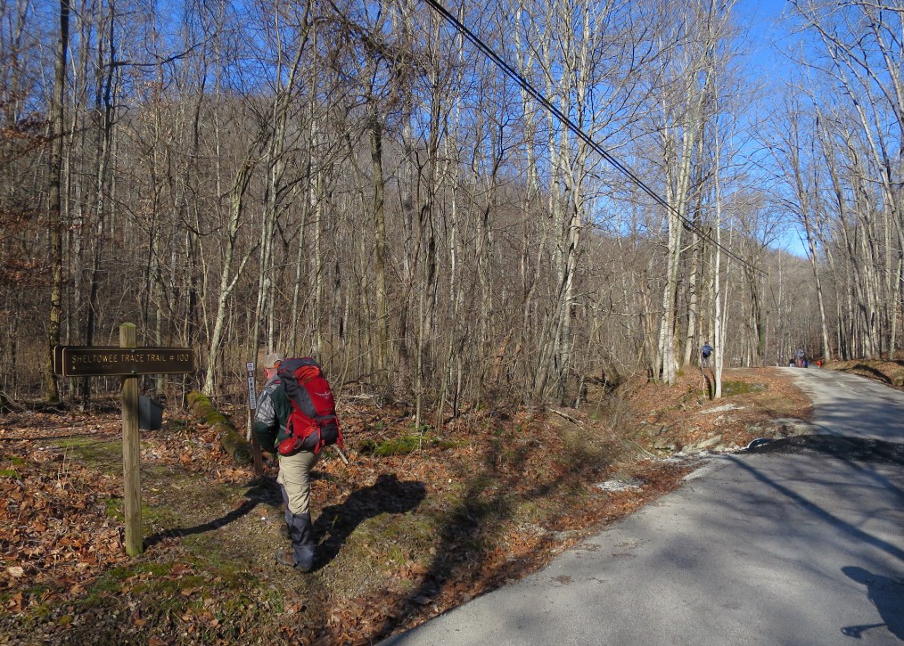
Team Alpha heading out for Sections Two.
We made it to the Trailhead at Clear Creek, and it was very frosty and cold. The temperature hovered around 22 and all of the hikers were sitting in their cars enjoying the last of the heat for some time. One by one they braved the cold and started to gather around and prepare for the trip. Steve Barbour arrived in the trusty old Sheltowee Buggy with a few volunteers from the Morehead/Cave Run Chapter who were also drivers for us.
We loaded our packs and climbed into the vans headed for Morehead. The ride did not take long and everyone was quiet. The sun was up and the sky was clear by the time we turned onto Main Street. We unloaded the vans and crossed the road to the steps of the Morehead Police Station for a quick picture. Forty-one of us headed west on Main Street and out into Hike 2.
We made our way on both sides of the sidewalk to the road crossing Highway 60 and on to Clearfield. The group started to string out at this point and those of us in the lead group turned at the Clearfield Post Office, wound our way through the neighborhood, and started the steady climb up Mill Branch.
Leaving the blacktop and heading back into the Daniel Boone National Forest near the head of Mill Branch at Clearfield.
Near the head of Mill Branch, the group stopped to take off our jackets and pullovers, as the temperature was still cool, but the sun and movement made the trek warm up quickly. We left the blacktop and hiked up the steep hillside to a graveled road. We walked a short distance around Forest Service Road 964 and dropped our packs near a small gate on the right side of the road.
We climbed the hill and explored the Amburgey Rocks. The formation was not the most picturesque because the views are obscured by the trees, but it is well worth the side trip. On our way back to the packs, we followed a small trail to the left (on the right if you are coming uphill) to a great view at the end of the point.
From Amburgey Rocks, the trail is predominately a flat roadway that is shared with mountain bikers. There are some small ups and downs but the hike was very enjoyable. One of the more interesting areas is the hike through the Big Limestone Knob area. The tops of the hills in this section are home to a long series of limestone boulders that reminded me of sections of Pennsylvania and Virginia on the Appalachian Trail. In fact, to me this section (other than the road walks), mirrored portions of the AT and were just as enjoyable. Steve Barbour met us on the roadway and checked on our progress.

A shot of the ridge top trail between Clear Creek and Stoney Cove.
We passed the day with laughter and stories that helped us ignore the cold temperatures and took away the dread of the forecasted cold night to come. We walked at a steady pace without “running” as I occasionally like to do. I learned some time ago on the Appalachian Trail- The slower hiker sees more, feels more, and experiences more. The AT taught me that the hike is more about what we see and enjoy than the miles we walk. The Sheltowee has a way of reinforcing this lesson.
To the top of the hill and down to Highway 801 and past the Cumberland District Ranger Station on the opposite side of the road. After a short climb on the blacktop, we arrived at and crossed the dam at Cave Run. At the end of the dam, the trail makes a slight turn to the right, goes around the gate, and climbs up a gravel road. The actual trail takes a sharp left and follows the lake shore, but a turn to the right took us on the old trail and to our camp spot for the night near the Stoney Cove Recreation area.
We dropped our packs and headed back to the van and Steve Barbour at the bottom of the hill to bring firewood and water to the campsite. We made several trips up the hill but soon had a roaring fire and a nice campsite for the evening. The campsite was relatively flat and spacious. I sat my tent up near a large log at the edge of a small clearing in hopes that the log would break any wind that might find its way to our camp that evening.
A couple of us walked back down to the lake and ate our dinner on a picnic table while watching a man throw an unusually large muskie lure into the water repeatedly with no positive result. We sat for some time in the sun and talked before making our way back up the hill to camp.
The cool temperatures soon found us huddled around the fire, but the friendship and piles of burning logs made the night enjoyable. Steve Barbour gave us the instructional talk and warned us of the multiple use sections of the trail that lay ahead of us for the next day. We stayed up late into the night, I think in part because no one wanted to climb down into their cold sleeping bags. Hikers one by one faded away into their tents until only a few of us remained at the fire. It was quiet and I sat for a long time watching the stars and the occasional thin clouds in the clear and amazing sky. Finally, I too wandered to my tent at about 11:30 p.m.
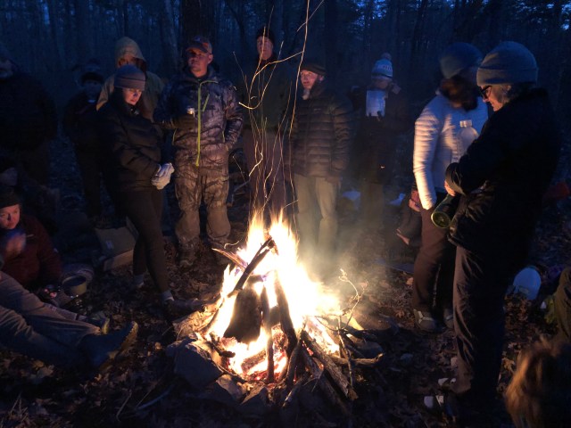
Campfires and friends make the night warmer and the time pass.
Day Two- Sunday
The night was cold but I managed very nice with only my Zpacks sleeping bag and a small down filled Costco blanket. I was up in the morning before the sun and ready to go in about 18 minutes. Some of the hikers were also up and huddled around the fire. I have found the best way to warm up is to move. I walked down the hill and loaded my “5-pound” drop back into the van and returned to my pack. With no other hikers ready to go, I decided to move on and I am glad that I did.
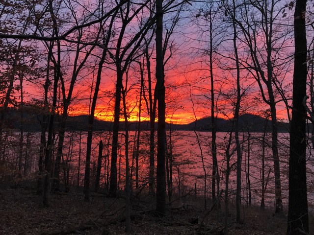
A beautiful sunrise over Cave Run Lake on Sunday morning.
I crossed the gravel road from our camp spot and back into the woods on the newly re-routed Sheltowee Trace. In the next few miles, my headlamp lit the way until about a half an hour into the hike the trail lit up red and orange from one of the most beautiful sunrises I have seen since my night on the top of Big Hump Mountain or maybe on the top of Max Patch on the AT.
I walked along the shore of Cave Run lake and watched the amazing show in the sky for nearly an hour until the blue sky of the day ate up all the red and orange. The trail wound its way back and forth, in and out of every cove and creek along the shoreline. I think I covered 67 miles in about a 5 mile section. Often times, I could look across a small cove and literally see the trail about 15 feet away but it could have been 200 miles because of the deep ravines and back water from the lake.
Near the head waters of the lake, the trail got a lot more interesting. The unusually heavy rain that we had experienced caused the lake to rise and in two separate locations, Caney Creek and Sulphur Branch had flooded the trail. I walked up stream and found a downed tree to shimmy across Caney Creek. Sulphur Creek was easier to cross, and I forded a low spot and climbed the hill and back to the trail.

One of the two flooded creek crossings due to high water in Cave Run Lake.
After Sulphur Creek, the trail was no longer flooded but the warnings about the condition of the multiple use trail came back to my mind with every step. I had seen signs of the horseback riders on sections of the trail, including those which were supposed to be restricted. In several sections, the yellow mud was eight and ten inch-deep and required hikers to travel through hundreds of feet of muck. I grew used to the sound of shoes struggling to gain release from the yellow clay as I walked along. The heavy rain and freezes of recent days turned the hoof prints into melting ankle breakers as the first sun of the morning bathed the trail in light. Our pace slowed tremendously through these sections as we made certain that every step fell in a solid spot that would support our weight.
At some point near the top of the hill, the horse trail veered to the left and the Sheltowee climbed right to the Ridgeline. From this point, the rest of Day Two offered an enjoyable series of ridge runs over to the Cedar Cliffs and the beautiful limestone formations and arches in that area. I encourage hikers to take a few minutes and walk off the trail for the 20 or so feet to the limestone above you in the Cedar Cliffs area.
Gunshots in the distance reminded me that we were nearly back to the Clear Creek Trailhead and the sounds traveled a long distance from the Clear Creek Shooting Range. Down the hill and through a beautiful, wide valley with old trees and electric green moss brought me back to the Ziplo Road and the Clear Creek Trail head.
In all, a very nice two days of hiking despite the struggles of the multi-purpose trail sections. All of the difficulties of temperature and distance were surmounted by movement, friendship, and true comradery that can be found in the Sheltowee Trace. We all left the parking lot tired but excited for section three and bigger challenges.

Bookie at Cave Run Lake Dam.
Find out more about the trail and the Sheltowee Trace Association here: Sheltowee Trace Association.

Great read , enjoyed it Stephen
LikeLike