By Stephen D. Bowling
In 1949, with Legislative approval, the Kentucky Department of Transportation initiated an effort to mark the significant historical events, places, and people across the Commonwealth. Using state funds, the committee planned to identify, design, and erect bronze markers at or near the site of these significant events. The state announced the program and asked the public to nominate sites with significant cultural impacts on the state or nation for review.

A committee of men and women reviewed the nominated sites and suggested 30 markers be among the first group to be considered in October 1949. The committee met and approved sites from this list, including Fort Boonesboro, the Wilderness Road, Abraham Lincoln’s birthplace, and Constitution Square in Danville. The site chosen closest to Breathitt County in the first round of roadside marker installations was the historic community of Indian Fields in Clark County. In fact, no locations in eastern Kentucky made the final round of the first nominations.
The years rolled by, and more than five hundred markers were erected across the state but none in Breathitt. A renewed emphasis on the program by newly elected governor Bert T. Combs expanded the effort across the state using excess funds from a 3% sales tax. Combs ensured that the state’s “forgotten section” received several markers during his administration. In 1961 and 1962, additional funds were added to the Department of Transportation’s budget to accommodate additions to the marker program in preparation for the 100th anniversary of the end of the Civil War.
At the request of Governor Combs, several citizens of Breathitt County formed a committee to identify significant local sites to nominate for the process. After a few meetings, the Breathitt County committee identified and nominated five significant sites. The Jackson Times announced the sites in a front-page story in June 1962.
Historic Markers To Be Erected
Tentative plans call for the installation of at least five historic markers in Breathitt County as a part of Governor Bert Combs’ state-wide program to erect markers during the centennial of the Civil War. Aimed primarily at the tourist trade, the program will also assist local residents in learning more about their county and state.
Mrs. Green Rose and Mrs. Frank Fletcher, co-chairmen for Breathitt County, said these five historic spots in the area have been tentatively selected for markers:
1. Spencer’s Livery Stables. The Proprietor of this establishment gained fame or notoriety (depending on whose side you favored) by selling horses to cavalrymen of both Rebels and Yankees during the Civil War. Tradition has it that he was not too particular about the source of the horseflesh he sold. Mr. Spencer’s establishment was located about one mile North of Jackson, near the site of the old Panbowl Mill.
2. Burial Grounds of Confederate Scout Jesse Spencer. Being a border state during the Civil War. Kentucky residents were “split down the middle” in their allegiance to the North and South. Spencer was a famed scout for the Confederate troops, and on January 7, 1862, he was slain in a foray by Captain Bill Strong’s Union Raiders. His grave and that of his wife, Elizabeth, is located near Wolverine, some three miles North of Jackson in the vicinity of the Jeff Howell Farm. Spencer, his wife, and one of their 12 slaves are said to share a common grave.
3. Election Day Massacre. This unfortunate event, though not of Civil War vintage, has a certain amount of historic interest. The pitched gun battle occurred at Clayhole on November 8, 1921. Five men died instantly, two later succumbed to wounds, and at least 19 others received wounds in the affray.
4. Captain Bill Strong’s Grave. Captain Strong was active in the Union Army during the Civil War a member of the “Greasy” 14th Regiment. This unit was formed of volunteer Kentucky cavalrymen. Strong later became embroiled in a bitter Breathitt County in the 1880s. He was killed from ambush when an old man John Akeman was accused of the crime, which occurred while Strong and a grandson were riding a mule near his home. The grandson was not injured; however, their faithful mule was fatally wounded.
5. The Wilson Callahan Homeplace. The century-old residence is located on KY 315, the Buckhorn Lake Road, near Longs Creek. Mr. Callahan, his son, Jackson, and grandson, Edward Callahan, then Sheriff of Breathitt County, were principals in the long and vicious Amis-Callahan-Strong feud that began in 1830 and continued for many years.
The five marker locations are not final, and the two ladies will welcome suggestions from Breathitt Countians concerning other historic spots of eventual interest to tourists and to the public. Mrs. Marie R. Turner is the district chairman of the marker program.
The Jackson Times, Thursday, June 14, 1962, Page 1
The marker suggestions were not final. Over the next few years, the sites changed. Much debate followed as members left and were replaced in the committee because of disagreements. Many of the old wounds that existed between families remained nearly 100 after the Civil War ended. By 1964, the first five sites had been finalized.
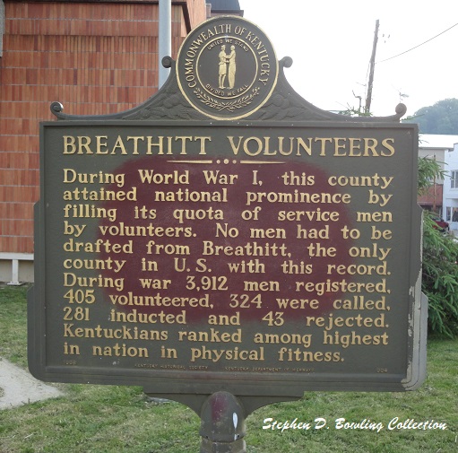
The Kentucky Historical Roadside Markers Commission made and installed state sign #641- Bloody Breathitt at the Courthouse, #669 was entitled Bitter Antagonism in the Howell Curve, #841- Quicksand- 1864 at the intersection of Highway 15 and 1098, #904- Breathitt Volunteers at the Courthouse, and #961- Breathitt County at the Courthouse.
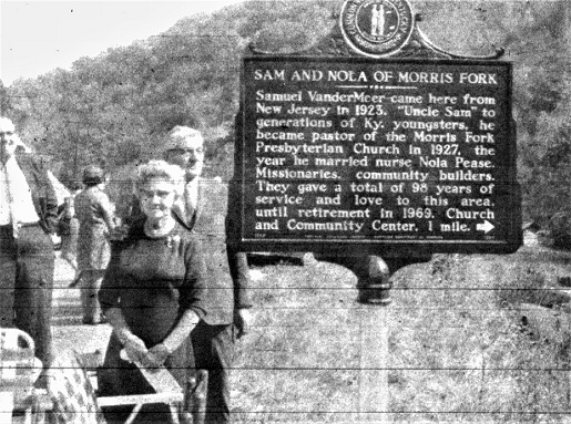
In 1969, friends and neighbors of Sam and Nola VanderMeer gathered at the mouth of Morris Fork on Long’s Creek on a sunny afternoon to unveil Breathitt County’s sixth roadside marker. The sign, #1289, was entitled Sam and Nola of Morris Fork and highlighted the work of two missionaries from New Jersey who came to the area in 1923. The sign stands at the intersection of Highway 28 and Morris Fork Road.
Sometime after it was installed, sign #641 Bloody Breathitt was removed from taken from the Courthouse Square by some unknown parties. The sign, which had been controversial since its installation, was feared lost for many years until it resurfaced in South Jackson in the 1990s. The sign returned to the public square when County Judge Lewis Henry Warrix installed a new post after several years of the sign being stored at the Breathitt County Museum.
As of 2023, only five historical markers remain in the county. One of the historical markers that were installed in Breathitt County does not exist today and will most likely never be replaced. The sign did not fall victim to vandals or someone who objected to its wording. The sign disappeared from its location because of bad drivers.
The missing marker, #669 Bitter Antagonism, was installed in the curve on the old Elijah Spencer farm three miles north of Jackson in May of 1964. Known then as the Howell farm and curve, the sign included the following text:
During the Civil War animosity between Union and Confederate sympathizers in Breathitt County led to deaths of 20 citizens and 44 CSA and USA men discharged or on furlough. They were killed in personal fights, ambushes, or by murders at their homes. CSA scout, Jesse Spencer, murdered and home wrecked by Bill Strong’s Raiders, Jan. 1863. Spencer buried on hill.
Highway Department records in the Spring of 1965 indicate that a driver skidded off the icy roadway and struck the sign. The bronze marker sustained some damage and was taken to Frankfort for repair. Workers completed the restoration and returned the sign to its place, moving the post back off the road an additional ten feet. Less than a year later, a driver drove off the roadway and struck and shattered the sign. The marker was recast and returned to the Howell Curve. Following a third crash in 1966, the state chose not to replace the roadside marker.
Since 1839, Breathitt County has come to embrace our history. The preservation efforts of J. Green Trimble, Josephine Bach, A. S. Sizemore, Charles Hayes, David Risner, Charles Riley, John J. Dickey, and hundreds of other genealogists and historians have preserved Breathitt County’s history for our generation, and most importantly, for future generations. These five remaining roadside markers tell only a tiny part of our rich and colorful history.
The question remains and will always remain- who will pick up the mantle and preserve our history for the coming generations. We must each do our part to ensure that our people, our culture, and our times are not lost and forgotten. Five little markers beside the roadway will do their part- will you do yours?
© 2023 Stephen D. Bowling
