
192 Trailhead to Catron Road
Researched by Stephen D. Bowling
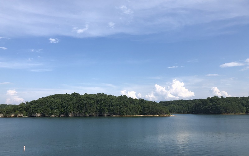
Laurel River Lake
Flooding has long been an issue for families that live along the Laurel River in southern Kentucky. In the early 1960s, both houses of Congress passed legislation to fund the construction of a dam to help alleviate these high water events. The act authorized the completion of the impoundment of the Laurel River approximately 2.3 miles above its confluence with the Cumberland River. Construction of the dam by the U. S. Army Corps of Engineers began in December 1964, and Laurel River Lake was impounded in 1974.

Through the years, the Corps of Engineers and other agencies have developed walking trails, bike trails, camping, and other recreational activities in the areas around the lake. After leaving the 192 Trailhead, the Sheltowee Trace drops over into Ben Branch of Sam’s Branch and eventually onto the banks of Craig Creek as you walk around the lake. Laurel Lake at Summer pool is 19 miles long and has approximately 206 miles of shoreline.
Holly Bay
The area known as Holly Bay is located on the west side of Laurel River Lake. A large and spacious campground is located on the hill just above the Sheltowee Trace as it weaves its way around Laurel Lake. The campground offers 75 sites for recreational vehicles that can be reserved in advance. There are many walk-in sites and non-reserved sites available on a first-come basis.
The popular campground features paved vehicle pads, gravel tent pads, fire rings, picnic tables, and lantern poles. Several sites have electricity and water. The campground does not have a public swimming beach, but one is located nearby at the spillway of Laurel River Lake dam.
The Holly Bay Marina, a full-service facility near the campgrounds, offers boat rentals, camping and fishing supplies, fishing licenses, and lake maps. The marina is open year-round and is a short walk down the hill from the Sheltowee Trace.
Laurel Dam
Started in 1964, the Corps of Engineers took ten years to construct the large death embankments of the Laurel River Dam. The final dam measures more than 282 feet tall and a quarter mile wide. Originally designed as a flood control project, the Corp of Engineers constructed a power generation plant near the dam’s base in 1974. The plant came on line and started producing electricity in 1977.
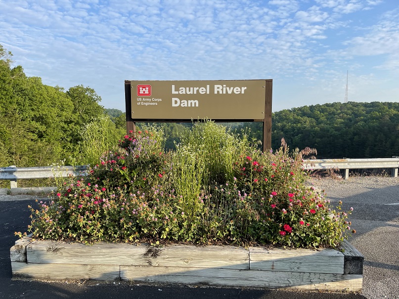
East Kentucky Power Corporation purchases all the hydropower generated at Laurel Lake and only operates the plant during periods of peak demand. They are required by contract with the Corps of Engineers to generate at least a 1/2 hour every other day and at least 700 MWH per week. The power plant averages an annual energy output of 67 million kilowatt hours.
Whitley County

Established on January 17, 1818, by the Kentucky Legislature, Whitley County became the 59th county created. Carved from the southern section of Knox County, the 445 square mile county was named for legendary Kentucky Frontiersman William Whitley. More than 38,000 acres of Whitley County are within the boundaries of the Daniel Boone National Forest.
The county seat of government is located in Williamsburg, but the city of Corbin is the county’s largest community, with more than 5,245 people. The region was first explored in 1750 by Dr. Thomas Walker, who noted the area’s rich resources, including many large virgin growth trees.
In 1883, the Louisville & Nashville Railroad constructed lines into the county to remove the timber. As of the 2010 Census, 36,712 people called Whitley County home.
The University of the Cumberlands and a satellite campus of Eastern Kentucky University are located in Whitley County.
Mouth of Laurel

The Laurel River runs for 42 miles through Laurel and Whitley County as it makes its way to the Cumberland River near a spot known as the Mouth of Laurel. Named for the thick clumps of laurel that grow along the steep banks of the river, the Laurel River was impounded in the early 1970s to create Laurel River Lake.
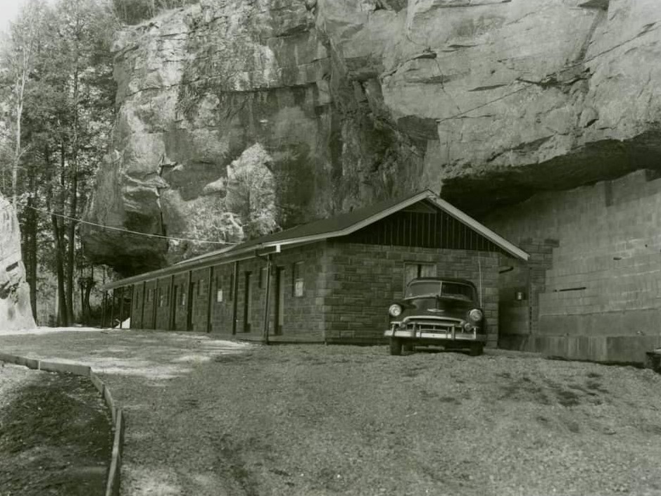
The mouth of Laurel is a very busy and popular boat launch for fishermen to access the large and smallmouth bass that can be found in the Cumberland River. A popular launch from the Mouth of Laurel takes tourists on a pontoon ride in the area. The area has been popular with tourists for many years and a small motel once operated under the cliff at the Mouth of Laurel.
Cumberland River
First discovered in 1750 by Dr. Thomas Walker, the Cumberland River flows for 688 miles from Baxter in Harlan County, Kentucky to Smithland, just north of Paducah. The river flows in a westerly course and was a vital route in the earliest days of westward expansion. The river has several major tributaries, including the Obey, Stones, Red, and Caney Forks, which drain a combined 18,000 square miles of terrain. The cities of Nashville and Clarksville, Tennessee were founded along its banks.

The Shawnees who hunted in the area for centuries called the large stream “Wasioto” and French traders later called it the “Riviere des Chaoyanons” or the River of the Shawnee. Dr. Walker renamed the mountains and river in honor of the financier of his journey, Henry, the Duke of Cumberland and Strathern. A hydroelectric plant was proposed for an area upstream from Cumberland Falls which would have limited the flow of water in the Cumberland River.
The Cumberland River is very popular today among fishermen and kayakers. Frequent white water trips are conducted by various companies and guide services on the river are available.
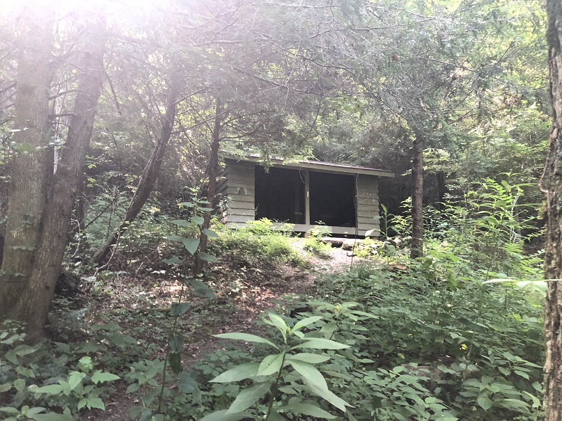
Bark Camp Cascades and Shelter

In the late 1970s and early 1980s, a series of Appalachian Trail-like shelters were constructed along the Sheltowee Trace with the plan to provide shelter and camping spots for hikers. Many shelters were planned, but few were ever constructed. Of those completed by volunteers and the United States Forest Service, only three remain today. One of those shelters is located on the hillside above the trail just beyond the Bark Camp Cascades. The shelter can comfortably house 5-6 hikers inside, and more hammock/tent space is available around the shelter.

The Bark Camp Creek Shelter is open for public use, but please follow all food storage best practices and certainly all of the tenants of the Leave No Trace Principals.
Star Creek Shelter
The Star Creek Shelter has survived several forest fires that burned near the structure which is still used by Sheltowee Trace hikers. More threatening to the continued existence of the shelter are the frequent hikers who have damaged the building and left garbage and debris. The shelter is free and open to the public.
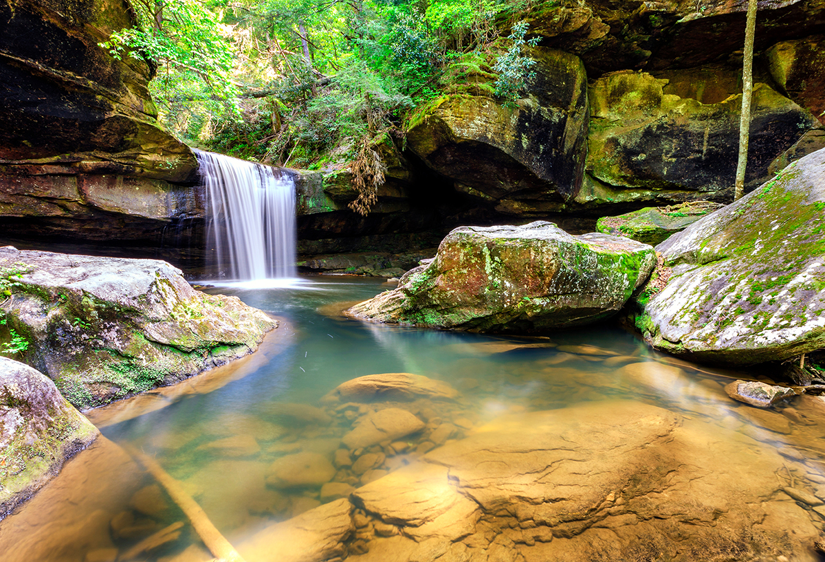
Dog Slaughter Falls
Dog Slaughter Falls is a fifteen-foot drop of water located near the point where Dog Slaughter Branch joins the Cumberland River in Whitley County. Two different theories have developed in time about the nature of the name. One relates that a group of hunting dogs was killed by a bear or creature just above the falls, and the other indicates a more sinister tale of a place where several animals were intentionally drowned. The spot, just off the Sheltowee Trace, is a very popular hiking destination along the Cumberland River.
Cumberland Falls
Known as “The Niagra of the South,” the Cumberland Falls is the only place in the Western Hemisphere where a moonbow is visible once per month when conditions are right. Dr. Thomas Walker discovered the falls during his exploration of Kentucky in 1750. He named the natural wonder and the river for his benefactor, the Duke of Cumberland.
The unique spot became a tourist attraction in the late 1800s. A large hotel, the Moonbow Inn, was constructed just feet from the edge of the falls and operated until a fire claimed the building in 1949. By the 1920s, investors announced plans to build a hydroelectric plant in the area and divert the water away from the falls. Thomas Coleman du Pont purchased the land and donated it to the Commonwealth of Kentucky in 1930.

On average, the falls are 68 feet wide and 125 feet tall. It is the second-largest waterfall east of the Mississippi River. Geologists believe that the falls started nearly 45 miles downstream at the edge of the Pottsville Escarpment and eroded to its present location.
Cumberland Falls State Park
Cumberland Falls State Resort Park is one of the 45 public parks operated by the state of Kentucky. The park currently consists of 1,657 acres and is named for its prominent feature, the 68-foot-tall Cumberland Falls. Cumberland Falls State Park officially opened on September 7, 1931. The park is located near Corbin, Kentucky, and was developed with the assistance of the business community to attract tourists. The waterfall had been a popular area to visit since the mid-1800s, but the isolation and terrible roads made it hard to access. The construction of the Falls Highway helped increase the number of visitors to Cumberland Falls. A large hotel known as the Moonbow Inn once stood near the falls’ edge. The Civilian Conservation Corps helped construct the Dupont Lodge, which today houses 51 rooms and a dining room.

The park is also the home of 44-foot Eagle Falls, across the river from the Sheltowee Trace. The section of the Cumberland River that includes the falls was designated a Kentucky Wild River by the Kentucky General Assembly. The forest in the park is also a dedicated State Nature Preserve.
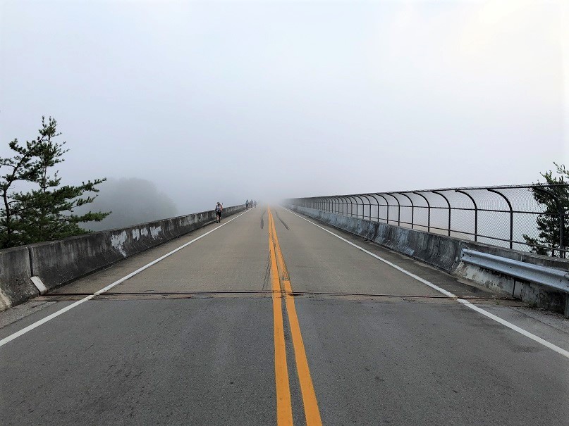
Edward Gatliff Bridge
Spanning the Cumberland River just upstream from Cumberland Falls is the scenic Gatliff Bridge. The stone-faced bridge has four arches that permit the river to pass through as it makes its way to the falls. The bridge was constructed in 1953 after years of lobbying and work by William Edward Moss Gatliff.

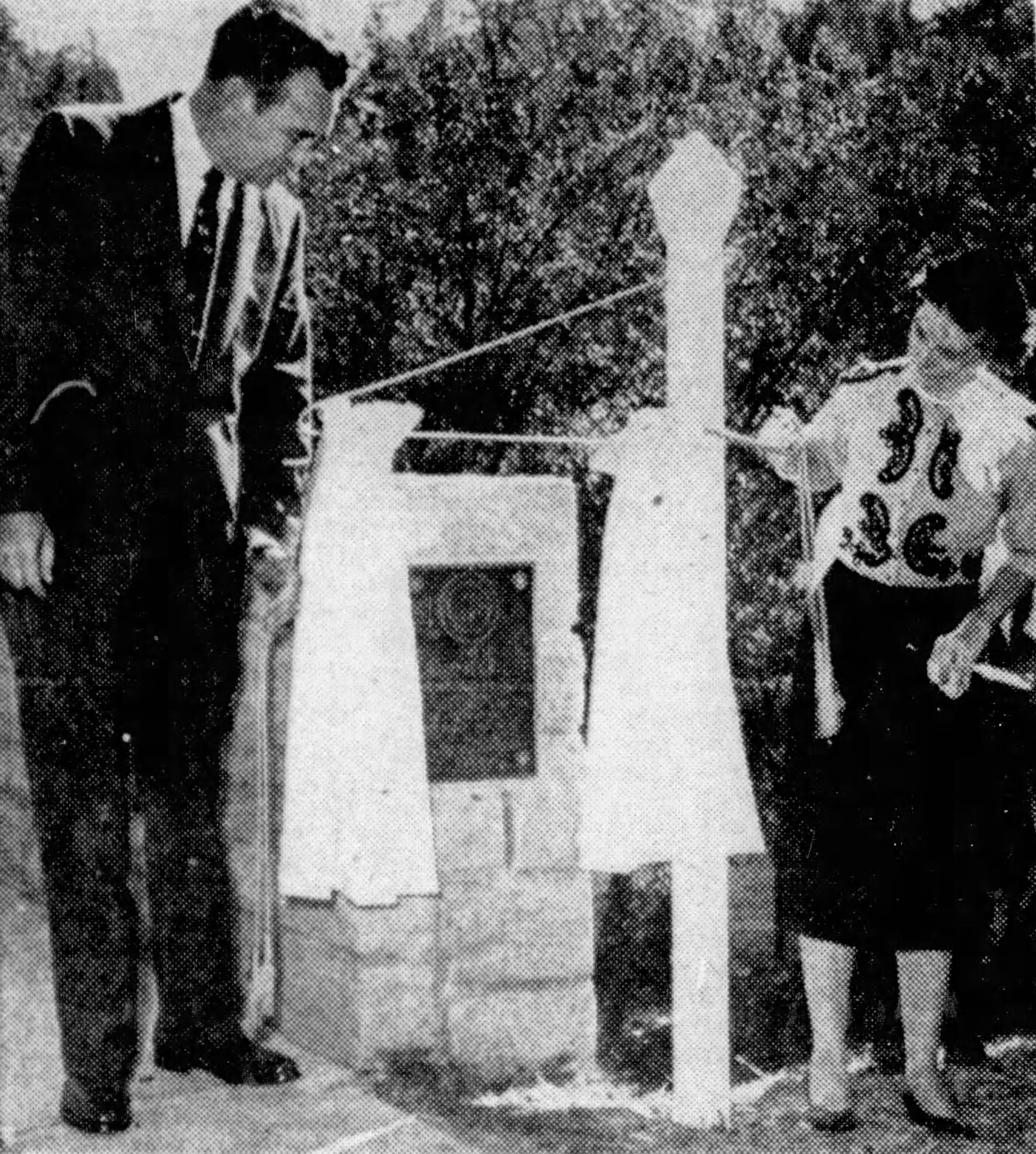
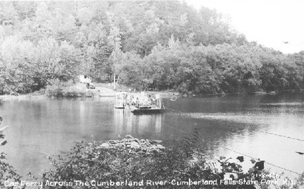
As a member of the Kentucky Highway Commission, Gatliff used his talents as an attorney and businessman to bring attention to the need to replace an outdated and sporadic ferry, which isolated much of Whitley County during high water. Gatliff campaigned to replace the ferry but did not see his work completed before his death on September 13, 1949.


McCreary County
Midway across the Edward Gatliff Bridge, hikers enter McCreary County, Kentucky. Created by the Kentucky State Legislature in 1912 and was the last of Kentucky’s 120 counties. The 431 square miles county was named for James B. McCreary, a former Confederate Army General, two-term Governor of Kentucky, United States Representative, and Senator from Kentucky. The County seat is Whitley City.
McCreary County, home to 16,888 residents in 2020, is unique in Kentucky as the only county without an incorporated city. The County Judge Executive and Fiscal Court administer all municipal functions in the county. The vast majority of the county is owned and controlled by the federal government, with 43 percent under the control of the Daniel Boone National Forest and 18 percent managed by the Big South Fork National River and Recreation Area.

The Stearns Coal Company started in what is now McCreary County in 1903 and controlled much of the economy throughout the 20th Century. Today, millions of visitors come to the county each year to visit Cumberland Falls, The Big South Fork Recreation Area, and the Big South Fork Scenic Railroad, which runs on many of the old coal railways in the area.
Thunderstruck Mountain

One of the most enjoyable gravel cliffs (I mean roadways) you will climb during your time on the Sheltowee Trace is Thunderstruck Hill. Named for the Thunderstruck Rapids in the Cumberland River at the foot of the hill, the climb is a long and steep exercise of pure joy and excitement. After an hour of uphill, you too will feel thunderstruck by the time you reach Highway 700. There is a reason this short section is called “The Hardest Mile.”

Highway 700
At the top of Thunderstruck Hill, the trail turns left onto Kentucky Highway 700. Highway 700 is a 16.54-mile stretch of roadway located entirely within McCreary County. The road runs from a boat ramp on the Big South Fork of the Cumberland River to the intersection with Highway 90 near Honeybee, Kentucky. Highway 700 drops down into the Indian Creek basin and climbs back out before leaving the roadway for a nice valley walk that parallels Highway 700. The Sheltowee Trace will follow Highway 700 for 1.47 miles before making a left turn into the woods for 1.35 miles to the Catron Road intersection.
Catron Road
Catron Road runs 1.66 miles north from its intersection with Highway 700. The Sheltowee Trace crosses 700 and runs parallel to Catron Road for about half a mile before the two paths diverge.

The Sheltowee Trace van will sit at the Highway 700 and Catron Road intersection to take you to your vehicle at Cumberland Falls State Park.
The Trace through this section is challenging and will test all of the hiking skills you have acquired. Your first real night in the woods will also require some new skills and some endurance. The days of slack packing the entire route are passed, but even more fabulous views and great times are ahead in the Big South Fork.
© 2022 Stephen D. Bowling

As always Steve, well done! Your posts make the hikes more enjoyable.
LikeLike