By Stephen D. Bowling
January 11, 1974 – Drivers on Highway 1110 rarely even notice or think about the swag. The straight stretch, referred to by many as “The Dip,” is smooth compared to the rest of the road. Through the years, millions have passed over the depression, but few know its history.
For much of its early existence, Breathitt County was isolated internally. The county covered a huge land mass of more than 700 square miles, embracing three large watersheds. Travel between the far reaches of the county and the county seat was often difficult. The County Court established an expansive network of road crews under a supervisor who directed his men with no other instructions than to “dig a road eight feet wide and maintain the same as to be passable.” This network of interconnected travel paths generally followed the major streams.
These early roadways helped connect the county but were never reliable. Not long before the Civil War, the Breathitt County Fiscal Court built the first macadam road from Jackson to the village of Quicksand, nearly six miles south. Others were built in the following decades.
By the early 1900s, the Kentucky Highway Commission expanded the work by helping to fund the construction of major arteries to promote commerce and facilitate trade across the Commonwealth. Breathitt County received funding to create or improve several roadways. The Kentucky-Virginia Highway (later Highway 15) was started, and what is now Highway 30 East and West and Highway 476 were envisioned. It was not until the 1950s that the last of the major arteries was added. Construction started on the Haddix-Altro-Gays Creek Road in the late 1950s following the flood of 1957.

On January 30, 1957, the North Fork of the Kentucky River reached 40.41 feet and flooded many homes in Breathitt County. Statewide, thousands were homeless, and at least eleven were killed. Hazard suffered record-setting flooding, but in Jackson, the waters spared much of the town. The largest casualty of the 1957 flood in Breathitt County was the vital connection bridge between Highway 15 and the community of Haddix.

The large three-section steel truss bridge crossed the Kentucky River near the Haddix L&N Depot. During the highest part of the flooding, the southern span, which connected the main bridge to the town of Haddix, buckled under the pressure and fell off its pillars into the rushing waters. Haddix was cut off except for a small walking bridge that residents “threw up” to cross the missing section using donated lumber.
The Kentucky Department of Highways (KDOH) studied the old bridge at Haddix and determined that a new bridge should be built. In April 1958, the KDOH started advertising for bids to complete Special Project 13-267 to replace the “Bridge over the North Fork of Kentucky River and Approaches near Haddix.” The total project was .318 miles and would construct a taller and wider bridge a few hundred yards south of the damaged bridge.
When the bids were opened on April 18, 1958, the R. R. Dawson Bridge Company of Bloomfield, Kentucky, won the contract with a low bid of $327,367. The Kentucky Department of Highways was not finished with improvements in that area.
The KDOH advertised for new road construction and improvements to rebuild and reroute the network of county roadways that led south from Haddix. The state proposed and funded a new roadway, the Haddix-Altro-Gays Creek Road, and awarded the first bid for construction in 1959. Construction crews built 8.717 miles of roadway from the end of the Haddix Bridge to Whick. The road was extended in 1963, 1966, 1968, 1970, and 1972, and the Department of Highways approved a series of small contract bids. When completed, the 15.6-mile road was redesignated as Kentucky Highway 1110.
The gravel surface of the new road was much smoother than the previous network of “mixed patched roadways,” and residents of Altro, Whick, Little, Saldee, Copeland, Dry Bread, and other communities along the North Fork and its tributaries welcome the access it provided. Later contracts started the blacktopping of the roadway in 1970, helping to make Highway 1110 a “priority roadway” in Breathitt County.
On January 9, 1974, the rain started to fall unabated. Over the next three days, 5.44 inches of “hard rain” fell and mixed with melting snow to fill area streams. The North Fork of the Kentucky River flooded its banks and rose to 36.50 feet by the time it crested on January 11. Conditions across the county deteriorated, and widespread flooding was reported. Several bridges were destroyed, and the National Guard was called to help inundated residents. Captain Lewis Henry Warrix and his men of Company C of the 201st Engineers rescued many from their flooded homes.
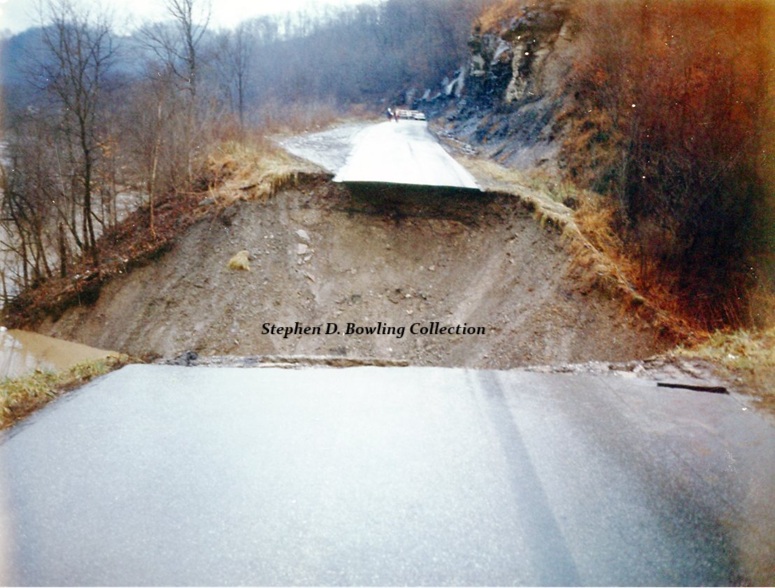
A driver headed to Jackson early on the morning of January 11 made it past the highwaters at Howard’s Creek and headed north toward Highway 15. He made it about a mile when he was stopped in his tracks near a spot where the roadway crossed near the mouth of a deep creek. There before him lay an open crevasse where Highway 1110 once lay. A huge section of highway was missing about a mile south of Dry Bread Hill. He stopped several other vehicles as they approached the chasm.

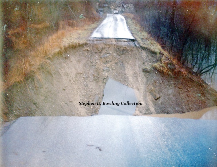
The Highway Department was notified, and barricades went up on both sides of the break. Officials came to the scene when water levels at Dry Bread dropped, and the roadway reopened. Engineers studied the failure and determined that there was not an easy fix. After some work, they decided the section needed to be rebuilt because of the limited options caused by the steep sandstone cliff near the scene.
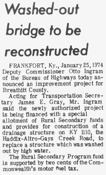
On January 25, 1974, Kentucky Department of Highways Deputy Commissioner Otto Ingram announced that an allotment from the Rural Secondary Road Fund had been awarded to reconstruct the damaged section of the roadway. The funds, available because of a 2-cent tax on fuel, would help fix the washed-away section and bring the dip up to a flat level.
Work started after the bids were opened and a contract awarded. Crews soon learned that the proximity to the rock cliffs and the North Fork would not allow them to “bring the grade up to create a flat surface.” As engineers supervised the work, construction crews packed rocks and large boulders in the divide. The workers slowly raised the level to the previous grade but could go up no further. When they could no longer “safely elevate the roadway,” engineers were satisfied that they had “done all possible to improve and replace the roadway.”
Highway 1110 was reopened, and in subsequent years, layers and layers of blacktop were placed on the “Dip” as the rebuilt section continued to compact and sink. The indention remained a dangerous portion of the roadway, claiming at least one life in recent decades. Guard rails were recently added to help improve safety in this stretch.
Today, “The Dip” is still a major feature traversed by everyone who travels on Highway 1110. Few remember the great chasm that opened on January 11, 1974 and the rebuilding effort that created this little depression on one of Breathitt County’s most traveled roadways.
© 2025 Stephen D. Bowling

My memory of this was as a high school student riding the bus to school. It seems like the driver would unload us students and we would walk across while the bus driver drove the bus down in and back up. We would then reload and go on our way to Breathitt High. I still think about that experience sometimes when I drive over that dip.
Rosie S
LikeLike