Dick Gap Overlook to Catron Road
Researched by Stephen D. Bowling
We continue our trek southward toward Burnt Mill Bridge as the trail turns North for one hike. August is usually hot and humid, and the trail gets tougher. Elevation change begins to increase as we hike toward the Big South Fork. The hiking does get a little more difficult, even for your experienced legs. The views and scenery improve to help you forget the increasing challenge.
Here is some information about the sites you will pass along the way.
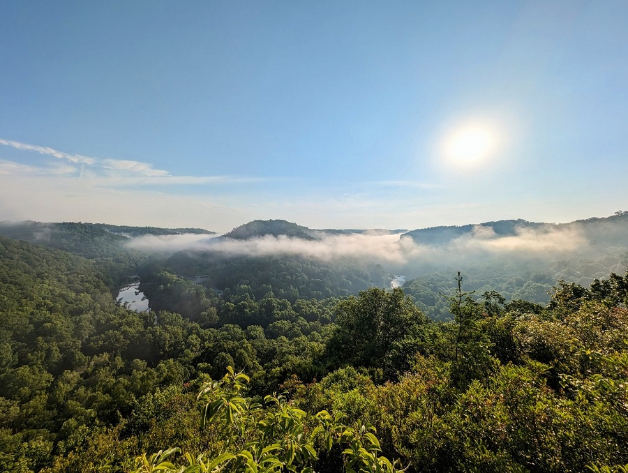
Dick Gap Overlook
Damage to the Blue Heron Bridge and its subsequent closure forced a change to the 2024 Chetowee Challenge. Hikers can no longer cross the tipple bridge until repairs have been completed. The changes forced the realignment of the hike to include a new beginning- Dick Gap Overlook. This high-elevation overlook provides a nice view of the Blue Beron Bend and the valley below. We will begin our August trek here after a short .3-mile or so walk from the Dick Gap Forest Service Road to the overlook.
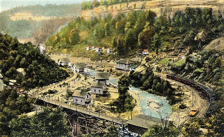
Blue Heron Mining Camp

The National Park Service operates the Blue Heron Historic Area along the Big South Fork River near Stearns Coal and Lumber Company Mine #18. The area features numerous historic interactive displays with information about the mines, the community, and the town that once operated here.

Opened in 1937, the Blue Heron Mines employed thousands at numerous operations until they “mined out” in December 1962. The large, historic tipple was completed in 1937 at the cost of $250,000 and was considered the most advanced coal facility in the world. Coal was hauled across the bridge and poured into train cars below. From Blue Heron, trains transport carloads of coal along the Kentucky and Tennesse Railroad to markets beyond the Big South Fork Valley. Good luck on the bridge for those who love heights.
Barthell and Comargo
The coal boom in southern Kentucky led to the establishment of many small coal towns. Operated by the coal companies, these areas were nearly self-contained communities designed to keep workers in the mines while providing some conveniences. The company’s housing was built uniformly to ensure the equality of the miners. Many of these coal camps became the first areas of McCreary County to be wholly integrated as a wide variety of nationalities and races worked together in the mines.

Barthell and Comargo were two coal camps located near the path of the Sheltowee Trace. The coal town of Barthell was located on Roaring Paunch Creek, and Comargo stood on the banks of the Big South Fork River near the mouth of Roaring Paunch Creek. These communities were dominated by the company boss, the company police (security guards), and the company store.
Company stores issued script currency that could only be redeemed at the company store for products that were usually of inferior quality and overpriced. Many would sell the script for a fraction of the face value to purchase items from other sources at cheaper prices. The system was designed to create perpetual debt, effectively prohibiting miners from moving away from the camp with their families. The construction of modern highways helped break the hold of the coal companies. As the coal booms slowed and many miners moved away in the mid-Twentieth Century, the coal camps were abandoned and faded into memory.
Reroute
A long-running issue with a local landowner helped the Sheltowee Trace move more of its trail off the blacktop and into the woods in 2021. The Trace makes a sharp left turn into the woods off Wilson Ridge Road onto the new reroute down to Rock Creek. The newest major reroute of the Shetowee Trace moved the trail from a long walk up Grassy Branch by abandoned coal mines to a hillside climb out onto Wilson Ridge.
After a short walk on Wilson Ridge Road, the trail will drop over the ridge to the left and onto a section of the Kentucky Trail on Slavey Hollow. The reroute removes about 5.11 miles of mixed trail and woods walking.
Rock Lick Creek
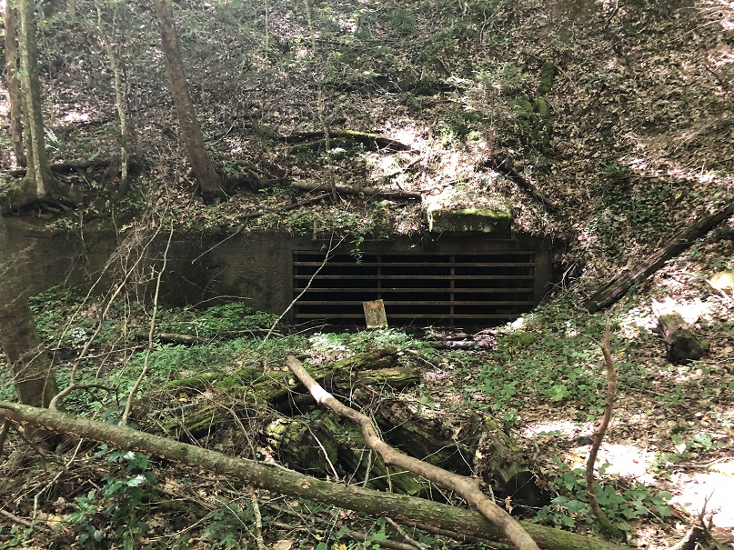
One of the broadest water crossings on the Sheltowee Trace is the wade through Rock Lick Creek. At normal levels, the creek is usually ankle to knee-deep. During high water and rain events, the water levels can reach more than 20 feet high in this area. The trail crosses the creek and makes its way up to Wilson Ridge, past several abandoned and partially sealed coal mines.

A highwater route exists for this area and includes a five-mile road walk around the flooded area on asphalt. It consists of some very enjoyable “climbs.”
K & T Bridge
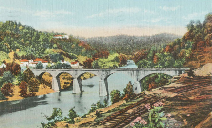
The K & T Bridge (also known as the Old Yamacraw Bridge) once carried hundreds of thousands of train and coal cars 565 feet across the Cumberland River for the Stearns Coal & Lumber. The bridge, consisting of five closed spandrels, was constructed in 1906 by the Collier Bridge Company of Indianapolis, Indiana, to bring coal out of Mines 10 and 11. It was the largest concrete structure in the world when it was constructed.

For almost 80 years, the bridge was in use and connected the communities of Oz, Paint Cliff, Yamacraw, and Worley. A downturn in the industry and reduced demand for coal closed the mines. The concrete span was abandoned in the 1980s. It stands today as one of the engineering marvels that Sheltwoee Trace hikers pass on their soon-to-be 354-mile trek.

Highway 92 Bridge

The Highway 92 Bridge over the Cumberland River from the Yamacraw Day Use Area to the Yamacraw-Bell Farm Road. The Highway 92 Bridge was once a welcomed landmark that signaled the opportunity to rest at the store at the bridge’s southern end.
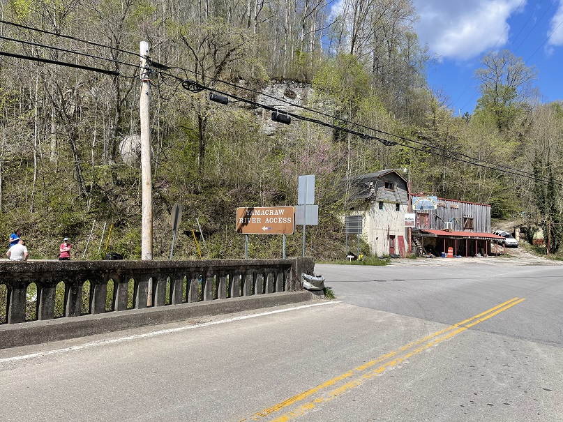
The Little South Fork Grocery was a refuge from the wilderness where hikers could get a cold drink and a snack along the trail. The store closed several years ago but was still standing to allow hikers to sit and rest in this shade. An arsonist set fire to and burned the building in 2022.
Yamacraw Trailhead
After following the Cumberland River for .73 miles, the trail enters the woods at the Yamacraw Trailhead. This parking area beside Highway 92 provides access to the trail along the river through some isolated areas. The parking area includes some informational signage and space for about ten vehicles. Additional parking and river access can be found under the bridge.

The Sheltowee Trace exits the Yamacraw parking area to the right and follows Highway 92 across the Yamacraw (Highway 92) Bridge.
Julia Lynn Falls
A short, seventy-five-foot side trail leads to Julia Lynn Falls. The falls measure 21 feet tall and average three feet wide during normal flow. The falls are in the Big South Fork Recreation area and were created when the waters of this small branch washed away the rock of the Grundy Sandstone Formation to create these plunge falls.

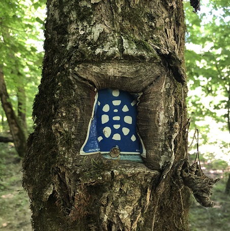
The falls are just a few feet from the Sheltowee Trace National Recreation Trail and are a great place to stop for a break and refill your water. The trail is marked by a small white triangle nailed to the side of a tree. The water flow is reduced and stops during prolonged periods without rain.
Princess Falls
Princess Falls is an eighty-foot-wide waterfall that plunges 13 feet over the rocks of Lick Creek as it makes its way to the Cumberland River. The falls were created when waters washed over the solid rocks of the Alvy Creek shale layer and undercut the Paragon sandstone layer below.
Water from more than 3,578 acres of Daniel Boone Forest drains into Princess Falls. The Falls are a short .10-mile hike up the creek from the Sheltowee Trace. The area is very popular with day hikers and is a favorite rest stop for Sheltowee Trace hikers.
Name Changes
The United States Park Service is evaluating the names of many places in its parks and property to ensure that all offensive names and places are altered to reflect a more modern understanding and be more inclusive. One of those areas being reconsidered in the ongoing effort is Negro Creek.
The source of the name that currently appears on United States Geological Survey Maps is not known. The Sheltowee Trace passes over a bridge at Negro Creek and continues southward toward Burn Mill Bridge.
In 2020, the Forest Service removed all signage in the area and has not announced a name change for the creek and area. Hikers can see the remnants of the signposts with the wording removed as they pass through the area.
Cotton Patch Shelter
One of the three remaining shelters on the Sheltowee Trace, the Cotton Patch Shelter, can accommodate up to ten sleepers. The wooden structure is located on a small knob overlooking the Cumberland River and Cotton Patch Creek. Based on the three-sided style popular on the Appalachian Trail, a series of shelters were planned for the Sheotowee Trace. Neglect, vandalism, and poor planning resulted in the removal of the shelters that were constructed but the final three. You have hiked past all three (Bark Camp, Star, and Cotton Patch) once you visit the Cotton Patch Shelter.

The Other People
Generations of native, European, and other peoples lived and thrived on the banks of the Cumberland River before the National Park Service acquired the properties in the 1930s. Evidence of their lives can be found all along our little walk. Old homesteads, wells, barns, foundations, and cemeteries help park visitors remember these first inhabitants. Along our walk this month, hikers will encounter numerous reminders.


Alum Ford

Alum Ford Primitive Campground is located seven miles west of Whitley City, Kentucky, near the Alum Ford Boat Launch, and can be accessed via Highway 700. The Sheltowee Trace passes through the primitive campground sites as it leads south. The areas included picnic tables, fire rings, six primitive campsites, and a pit toilet.

Bridge Out- Now In

In late 2021, one of your friendly neighborhood trees claimed another of the Big South Forks bridges. About .35 miles south of Yahoo Falls, a large span of a creek crossing bridge was destroyed by several falling trees. The crossing was very difficult and required some teamwork. The rock on the south side of the “bridge” is steep and slick. On June 22, 2024, volunteers and Forest Service representatives worked several hours to reconstruct the bridge over the small creek. After a full day’s work, hikers along this section will no longer have to work through this dangerous section. They can now cross the new bridge.

Yahoo Falls
Yahoo Falls was once considered Kentucky’s tallest waterfall at 113 feet. After recent discoveries, it ranks seventh, with Crabtree Falls claiming the top spot with a plunge of 145 feet. Yahoo Falls is one of the most famous waterfalls along the Sheltowee Trace despite its fall from the top. Located near Yahoo Arch, the falls are surrounded by the Yahoo Falls Recreation Area, created in 1960.

Legend holds that Daniel Boone shot and killed a large harry ape-man near these falls in the mid-1770s. He called the beast a “Yahoo” from characters in his favorite book, Gulliver’s Travels.
Cumberland River
First discovered in 1750 by Dr. Thomas Walker, the Cumberland River flows for 688 miles from Baxter in Harlan County, Kentucky, to Smithland, just north of Paducah. The river flows in a westerly course and was a vital route in the earliest days of westward expansion. The river has several major tributaries, including the Obey, Stones, Red, and Caney Forks, which drain more than 18,000 square miles of terrain. Nashville and Clarksville, Tennessee, were founded along its banks.

For centuries, the Shawnees who hunted in the area called the large stream “Wasioto.” French traders later called it the “Riviere des Chaoyanons” or the River of the Shawnee. Dr. Walker renamed the mountains and river in honor of the financier of his journey, Henry, the Duke of Cumberland and Strathern. A hydroelectric plant was proposed for an area upstream from Cumberland Falls, which would have limited the water flow in the Cumberland River.
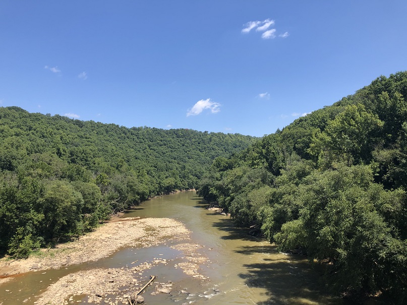
The Cumberland River is very popular today among fishermen and kayakers. Frequent white water trips are conducted by various companies, and guide services on the river are available.
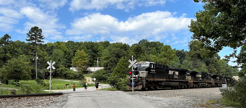
CSX Tracks
After leaving the Flat Rock Church, hikers will cross Highway 27. About twenty feet from the roadway is the second crossing of a CSX Railroad track. Many train carloads of chemicals and vehicles are carried across this railway owned by Chessie and Seaboard Express (CSX) Railroad. Do not attempt to crawl under or through a stopped train. Wait and be safe.
US Highway 27

The Sheltowee Trace parallels US 27 near the Highway 27 Trailhead. Highway 27 is the primary roadway that Connects Somerset to Whitley City and Oneida, Tennessee. The Trace will cross Highway 27 at the Flat Rock Church.
US 27 runs for 201.12 miles in Kentucky, beginning at Strunk in Whitely County near the community of Pine Knot. The roadway runs through Somerset, Stanford, Nicholasville, Lexington, Paris, Cynthiana, Falmouth, and Newport communities. At Newport, the highway crosses the Taylor Southgate Bridge over the Ohio River to Ohio. US 27 is 1,373 miles long and reaches from Miami, Florida, to Fort Wayne, Indiana. The road was first designated in 1926.

Flat Rock Missionary Baptist Church
The Sheltoweee Trace crosses US 27 at the Flat Rock Church near Marshes Siding on the L&N Railroad. The Flat Rock Missionary Baptist Church is located beside Highway 27, approximately 4.87 miles from Whitley City. The church provides an opportunity to stop and rest before crossing the roadway and starting the descent on the North Fork of Big Creek to the Cumberland River.
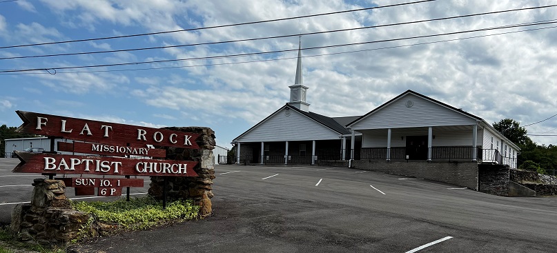
The Missionary Baptist movement emerged in the 19th Century and resulted from a split in the Baptist church over the need for outreach or mission work. The Missionary Baptist favored community involvement and sponsoring mission trips to serve underprivileged areas in the United States and worldwide.
The opposing factions became known as the Primitive Baptists following the division. Many churches in Eastern Kentucky are Missionary Baptist because of community outreach efforts in the mountains. The Flat Rock Missionary Baptist Church is welcoming to hikers and is a cooperative partner with the Sheltowee Trace Association. The church provides a spigot beside the building for hikers passing through the area who need water.
Stearns
Stearns, Kentucky, was founded in 1902 by the Stearns Coal and Lumber Company as their center of operations in southern Kentucky. At its peak, Stearns controlled more than 200 square miles. Stearns was the site of the world’s first all-electric sawmill, but its operations extended far beyond the city. Stearns was the largest coal-producing company in the state for many years, with more than 2,200 people living and working in its 18 coal camps in the surrounding area.

Stearns was a model community for its day and was considered state of the art for Kentucky. At its peak, the “clean little town” boasted more than 100 buildings painted the company’s colors of white with green trim. The city was home to hundreds of residences, a freight depot, the company office building, pool halls, a theater, the large Stearns Hotel, and the mammoth company store. The company also provided municipal water, electricity, steam heat, tennis courts, a golf course, and a baseball field for its employees and their families.

The community was named for Justus Smith Stearns (1845 – 1933) of Ludington, Michigan, a wealthy American lumberman who owned an interest in numerous companies. Stearns became known as the “American Pine King” because of his successful timber operations in Kentucky, Wisconsin, Florida, Michigan, and the Pacific Northwest. By 1903, Stearns owned and controlled more than 180,000 acres of timber and coal interests in Kentucky and Tennessee. Stearns, Kentucky, is 4.0 square miles and was home to 1,365 residents in 2020.

Barren Creek Horse Camp
About 7.25 miles from the end of our hike, the Barren Fork Horse Camp, located in the Stearns District of the Daniel Boone National Forest, is a popular campground for horseback riders who enjoy the forest setting. The trail does not pass through the campground but skirts the facility. Several interconnecting trails provide miles of riding pleasure. The campground offers 41 campsites with room for horse trailers and RVs up to 35 feet. Picnic tables, vault toilets, and potable water are available, and a small fishing pond is on site.

The Barren Fork Horse Camp was once the site of a coal mining town operated by the Barren Fork Mining and Coal Company. The mines operated from 1881 to 1935, producing what was considered some of the best quality low-sulfur coal in McCreary County. The Barren Fork Post Office served this small community from 1899-1965, and many old foundations of community buildings can be seen. More than 100 families lived and worked in the mining community. The property was then sold to the United States in 1936.
Chestnut Flats
The Sheltowee Trace ascends the banks of Indian Creek and continues uphill from Barren Fork to Highway 700. On the opposite side of the creek, Chestnut Flats is a 1,170-foot rise that was once covered with large American chestnut (Castanea dentata) trees. The chestnut tree was a fast-growing member of the beech family and was the predominant tree in the forests of Appalachia. The broad canopies of these trees provided shade, and the chestnuts were a staple crop for humans and livestock into the beginning of the 20th Century.

In 1904, New York Zoological Gardens foresters noticed that two chestnut trees were dropping leaves and dying. After some research, botanists determined that the tree had accidentally been infected with cryphonectria parasitica, a parasitic fungus native to southeast Asia. Within 20 years, the blight, as it was known, had killed as many as 4 billion trees. The loss of these extensive forests devastated the Appalachian economy and altered mountain lifestyles.

Work is continuing by the American Chestnut Foundation and the United States Department of Agriculture to create hybrids and blight-resistant trees. Some success has been achieved, but much work remains. Challenge hikers who complete the Sheltowee Trace Challenge will hike within ten feet of at least three American chestnut trees.
Catron Road
The Sheltowee Trace Hike 9 ends where we left off on Hike 8- at Catron Road on the top of the ridge.

Have a great hike- there are only beautiful days ahead.
© 2024 Stephen D. Bowling
